


Transportation
Airports
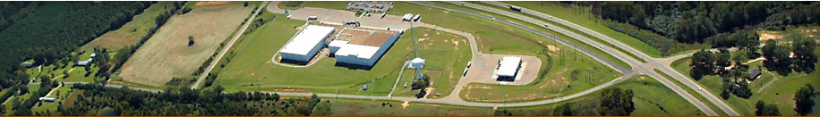
Jackson-Evers International Airport
Simpson County residents have access to air travel through Jackson-Evers International Airport. The Jackson-Evers International Airport, located five miles east of Jackson, and 30 miles north of Simpson County, is a United Customs port of entry and a designated Foreign Trade Zone (FTZ 158). The airport is served by two parallel 8,500-foot runways and an all-weather Category III precision approach landing system, and it is attended 24 hours a day, seven days a week. Eight airlines provide 40 non-stop flights per day to 12 destinations. Aircraft fuel, repairs, and charters are available through a full-service, fixed-based operator. Located at the airport are air cargo carriers, freight forwarders, and a customs broker. Car rentals, restaurants, and ground handling are also on the premises.
Passenger Carriers
The Jackson-Evers International Airport currently offers passenger service from:
Atlantic Southeast Airlines (ASA)
American Eagle
Continental Express
Comair
Delta Air Lines
Northwest Airlines
Southwest Airlines
US Airways Express
Magee Municipal Airport
The City of Magee owns and operates an airport in Simpson County with a 3100 foot long runway. Please call 601-849-3571 for more information.
Highways/Interstates
Simpson County has an ideal transportation infrastructure network. From interstate and U.S. highway systems, to rail and seaports, business and industry have advantages of receiving raw materials and getting finished goods to markets quickly. Simpson County is within a single day’s drive to all of the major metropolitan areas of the Southeastern and Midwestern U.S.
Interstate and U.S. Highway System
Simpson County’s highway system provides excellent north-south and east-west access to major U.S. markets. U.S. Highway 49, a divided, four-lane highway runs north-south through Simpson County and connects the County and its people to Jackson, MS to the north and Hattiesburg, MS and the Mississippi Gulf Coast to the South. U.S. Highway 49 also connects Simpson County to Interstates 55, 20, and 59 within a 40 minute drive.
Maps
Simpson County Interactive Map
Rail
Simpson County is served by the Canadian National Railway. Canadian National (CN) maintains two main lines running north to Memphis, Tennessee; these lines converge in Jackson, where the railroad has a major terminal switching yard and office/shop facilities. The lines again diverge from Jackson to run south to New Orleans and Baton Rouge, Louisiana, and southeast to Mobile, Alabama, via Hattiesburg, Mississippi. CN also operates an automotive facility in Jackson that serves the four-state area of Mississippi, Alabama, Tennessee, and Louisiana. Jackson is the headquarters for CN’s United States central sub-region.
CN’s Rail Service is reliable, efficient and cost-effective transportation. They provide access to 75% of the population in the U.S. and Canada with their unique rail network along with access to major ports for all your global shipping needs.
Maps
Simpson County Interactive Map
Seaports/Waterways
Port of Gulfport
The Mississippi State Port Authority is an Enterprise Agency of the State of Mississippi and is responsible for the daily operations of the Port of Gulfport. The Port of Gulfport is a bulk, break-bulk and container seaport which encompasses 204 acres, has nearly 6,000 feet of berthing space and averages over 2 million tons of cargo a year shipping over 200,000 TEU’S. The Port of Gulfport has gained a solid reputation as the second largest importer of green fruit in the United States and the 3rd busiest container port on the US Gulf of Mexico. The Port of Gulfport has direct access to Hwy 49 and it is only 10 minutes from Interstate 10. Simpson County is located approximately 110 miles from the port.
Port of Vicksburg
The Port of Vicksburg is located on a slack-water harbor. This 422-acre port consists of a harbor channel 9550 feet long, with minimum 300-foot width, and 12-foot minimum depth. An approach channel 4850 feet long with 150-foot minimum width and 12-foot minimum depth, connects the harbor channel to Vicksburg Harbor. The Port maintains a 150-ton crane, two 15-ton overhead cranes, all-weather loading and unloading, and 129,000 square feet of insured and sprinklered warehouse space. A rail and road loop allows direct access from barge to truck to rail. Liquid warehouse facilities, barge fleeting, and marshalling services, and barge cleaning and refurbishing services are available.
Simpson County is located approximately 70 miles from the port.
Port of New Orleans
The Port of New Orleans is the only deepwater port in the United States served by six class one railroads. This gives port users direct and economical rail service to or from anywhere in the country. The Port’s facilities include 22 million square feet of cargo handling area and more than 6 million square feet of covered storage area. Simpson County is located approximately 160 miles from the port.